


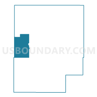
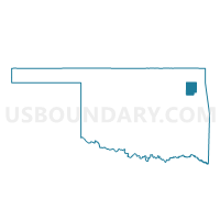
Voting District 20, Mayes County, Oklahoma
About
Outline

Summary
| Unique Area Identifier | 654452 |
| Name | Voting District 20 |
| County | Mayes County |
| State | Oklahoma |
| Area (square miles) | 37.82 |
| Land Area (square miles) | 37.81 |
| Water Area (square miles) | 0.01 |
| % of Land Area | 99.97 |
| % of Water Area | 0.03 |
| Latitude of the Internal Point | 36.28939180 |
| Longtitude of the Internal Point | -95.39742870 |
Maps

Graphs
Select a template below for downloading or customizing gragh for Voting District 20, Mayes County, Oklahoma


Neighbors
Neighoring Voting District (by Name) Neighboring Voting District on the Map
- Voting District 101, Mayes County, OK
- Voting District 11, Mayes County, OK
- Voting District 12, Rogers County, OK
- Voting District 15, Mayes County, OK
- Voting District 22, Rogers County, OK
- Voting District 22, Mayes County, OK
- Voting District 241, Mayes County, OK
Top 10 Neighboring County Subdivision (by Population) Neighboring County Subdivision on the Map
- Claremore CCD, Rogers County, OK (44,138)
- Pryor Creek CCD, Mayes County, OK (18,868)
- Inola CCD, Rogers County, OK (6,359)
- Adair CCD, Mayes County, OK (6,347)
Top 10 Neighboring Place (by Population) Neighboring Place on the Map
Top 10 Neighboring Elementary School District (by Population) Neighboring Elementary School District on the Map
Top 10 Neighboring Unified School District (by Population) Neighboring Unified School District on the Map
- Pryor Public Schools, OK (13,596)
- Sequoyah Public Schools, OK (6,315)
- Chouteau-Mazie Public Schools, OK (5,443)
Top 10 Neighboring State Legislative District Lower Chamber (by Population) Neighboring State Legislative District Lower Chamber on the Map
Top 10 Neighboring State Legislative District Upper Chamber (by Population) Neighboring State Legislative District Upper Chamber on the Map
Top 10 Neighboring 111th Congressional District (by Population) Neighboring 111th Congressional District on the Map
Top 10 Neighboring Census Tract (by Population) Neighboring Census Tract on the Map
- Census Tract 408, Mayes County, OK (6,347)
- Census Tract 404, Mayes County, OK (5,633)
- Census Tract 401, Mayes County, OK (4,809)
- Census Tract 506.04, Rogers County, OK (3,744)
- Census Tract 403, Mayes County, OK (3,696)
- Census Tract 505.01, Rogers County, OK (2,980)